Mediterranean forest ecosystem observatory (FORET) : Observation Service of the Montpellier Research Observatory of Environment (OSU OREME)
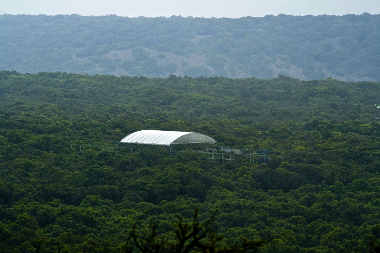
Data from the 'Mediterranean forest ecosystem observatory' (FORET): Observatory of Mediterranean forest ecosystems and vulnerability to climate change: gas and energy exchanges, growth, plant and animal dynamics, .... This observatory is part of the Montpellier Research Observatory of Environment (OSU OREME, oreme.org). It is labelized in the framework of IR ICOS-France. It consists in different observing tasks: AIGLE ; Fires ; GMAP ; Puéchabon.
Simple
- Date (Revision)
- 2025-12-18
- Identifier
-
56fbc297-87f0-4a0d-b034-dabc2c25bd54
- Status
- On going
- Maintenance and update frequency
- data is updated in intervals that are uneven in duration Irregular
-
GEMET
-
AGROVOC
- Theme
-
-
FORET
-
Phenology
-
IR ICOS-France
-
- Access constraints
- limitation not listed Other restrictions
- Other constraints
-
Licence ouverte / Open Licence
- Use limitation
-
This work is licensed under the Licence ouverte / Open Licence ( https://www.etalab.gouv.fr/licence-ouverte-open-licence )
- Spatial representation type
- vector data is used to represent geographic data Vector
- Metadata language
- EnglishEnglish
- Character set
- 8-bit variable size UCS Transfer Format, based on ISO/IEC 10646 UTF8
))
- Reference system identifier
-
EPSG
/4326
- Topology level
- geometry objects without any additional structure which describes topology Geometry only
- Geometric object type
- bounded, connected 2-dimensional geometric primitive, representing the continuous image of a region of a plane Surface
- Geometric object count
- 5
- Distribution format
-
-
CSV
()
-
- OnLine resource
-
See FORET data on OSU OREME data portal
(
WWW:LINK-1.0-http--link
)
- OnLine resource
-
See FORET information on OSU OREME website
(
WWW:LINK-1.0-http--link
)
Conformance result
- Date (Publication)
- 2010-12-08
- Explanation
-
See the referenced specification
- Pass
- Yes
Conformance result
- Date (Publication)
- 2008-12-03
- Explanation
-
See the referenced specification
- Pass
- Yes
- Statement
-
Measurements: Fire Geographic Information System observing task: Annual burned area, GIS raster layer ; Flux measurements and garrigue ecosystem functioning: Puéchabon site observing task: Flow and biomass measurements ; Mediterranean-Alpine gradient of forest plots observing task: In each plot (1000 m²). the position and dimensions (diameter and height) of trees have been recorded. and the growth of all threes in the inner part of the plot (ca. 314 m²) has been estimated through dendrochronology.
- File identifier
- 56fbc297-87f0-4a0d-b034-dabc2c25bd54 XML
- Metadata language
- EnglishEnglish
- Character set
- 8-bit variable size UCS Transfer Format, based on ISO/IEC 10646 UTF8
- Hierarchy level
- information applies to the dataset Dataset
- Date stamp
- 2025-12-18T12:00:00
- Metadata standard name
-
ISO 19115:2003/19139
- Metadata standard version
-
1.0
- Dataset URI
-
OSU-OREME-FORET
Overviews
Spatial extent
Provided by