Pollution downstream of mining sites observatory (POLLUMINE) : Observation Service of the Montpellier Research Observatory of Environment (OSU OREME)
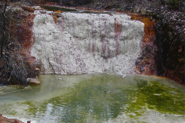
Data from the 'Pollution downstream of mining sites observatory' (POLLUMINE): Observation of pollution (physico-chemical parameters, concentrations in metals and metalloids, microbiology) and biological adaptability (phytoremediation) downstream of mining sites.. This observatory is part of the Montpellier Research Observatory of Environment (OSU OREME, oreme.org). It consists in different observing tasks: Carnoules ; Fauna of the soil on old mining sites ; Noccaea caerulescens.
Simple
- Date (Revision)
- 2025-12-18
- Identifier
-
ac9a8cb5-51b7-4d54-9b8c-3e30d09ed5b4
- Status
- On going
- Maintenance and update frequency
- data is updated in intervals that are uneven in duration Irregular
-
GEMET
-
AGROVOC
- Theme
-
-
POLLUMINE
-
- Access constraints
- limitation not listed Other restrictions
- Other constraints
-
Licence ouverte / Open Licence
- Use limitation
-
This work is licensed under the Licence ouverte / Open Licence ( https://www.etalab.gouv.fr/licence-ouverte-open-licence )
- Spatial representation type
- vector data is used to represent geographic data Vector
- Metadata language
- EnglishEnglish
- Character set
- 8-bit variable size UCS Transfer Format, based on ISO/IEC 10646 UTF8
- Reference system identifier
-
EPSG
/4326
- Topology level
- geometry objects without any additional structure which describes topology Geometry only
- Geometric object type
- bounded, connected 2-dimensional geometric primitive, representing the continuous image of a region of a plane Surface
- Geometric object count
- 5
- Distribution format
-
-
CSV
()
-
- OnLine resource
-
See POLLUMINE data on OSU OREME data portal
(
WWW:LINK-1.0-http--link
)
- OnLine resource
-
See POLLUMINE information on OSU OREME website
(
WWW:LINK-1.0-http--link
)
Conformance result
- Date (Publication)
- 2010-12-08
- Explanation
-
See the referenced specification
- Pass
- Yes
Conformance result
- Date (Publication)
- 2008-12-03
- Explanation
-
See the referenced specification
- Pass
- Yes
- File identifier
- ac9a8cb5-51b7-4d54-9b8c-3e30d09ed5b4 XML
- Metadata language
- EnglishEnglish
- Character set
- 8-bit variable size UCS Transfer Format, based on ISO/IEC 10646 UTF8
- Hierarchy level
- information applies to the dataset Dataset
- Date stamp
- 2025-12-18T12:00:00
- Metadata standard name
-
ISO 19115:2003/19139
- Metadata standard version
-
1.0
- Dataset URI
-
OSU-OREME-POLLUMINE
Overviews
Spatial extent
Provided by