Hydrogeophysics in drilling observatory (FORAGE) : Observation Service of the Montpellier Research Observatory of Environment (OSU OREME)
Data from the 'Hydrogeophysics in drilling observatory' (FORAGE): In-situ study of subsurface dynamics using multi-parameter and multi-method drilling observations: imaging and temporal monitoring of geophysical, hydrogeological and hydrogeochemical parameters.. This observatory is part of the Montpellier Research Observatory of Environment (OSU OREME, oreme.org).
Simple
- Date (Revision)
- 2025-12-18
- Identifier
-
e3ab3f44-6302-46af-8143-fd9ea72494e1
- Status
- On going
- Maintenance and update frequency
- data is updated in intervals that are uneven in duration Irregular
-
GEMET
-
AGROVOC
- Theme
-
-
FORAGE
-
Hydrogeophysics
-
- Access constraints
- limitation not listed Other restrictions
- Other constraints
-
Licence ouverte / Open Licence
- Use limitation
-
For any use of data of the Observatory of Hydrogeophysics in drilling, please cite OSU OREME and Géosciences Montpellier in thanks. We also recommend to contact the person responsible of the type of data used to talk about data acquisition and use. Finally if your work results in a publication, please send us the PDF version.
- Use limitation
-
This work is licensed under the Licence ouverte / Open Licence ( https://www.etalab.gouv.fr/licence-ouverte-open-licence )
- Spatial representation type
- vector data is used to represent geographic data Vector
- Metadata language
- EnglishEnglish
- Character set
- 8-bit variable size UCS Transfer Format, based on ISO/IEC 10646 UTF8
))
- Reference system identifier
-
EPSG
/4326
- Topology level
- geometry objects without any additional structure which describes topology Geometry only
- Geometric object type
- bounded, connected 2-dimensional geometric primitive, representing the continuous image of a region of a plane Surface
- Geometric object count
- 5
- Distribution format
-
-
CSV
()
-
- OnLine resource
-
See FORAGE data on OSU OREME data portal
(
WWW:LINK-1.0-http--link
)
- OnLine resource
-
See FORAGE information on OSU OREME website
(
WWW:LINK-1.0-http--link
)
- OnLine resource
-
borehole_station
(
OGC:WMS
)FORAGE stations WMS
- OnLine resource
-
borehole_station
(
OGC:WFS
)FORAGE stations WFS
Conformance result
- Date (Publication)
- 2010-12-08
- Explanation
-
See the referenced specification
- Pass
- Yes
Conformance result
- Date (Publication)
- 2008-12-03
- Explanation
-
See the referenced specification
- Pass
- Yes
- Statement
-
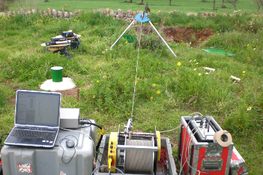
Measurements: Acoustic Borehole Imagies ; Borehole fluid properties ; Caliper ; Conductivity Temperature Pressure probe ; Electrical resistivity tomography ; Flowmeter ; Focalised Electrical probe ; Full Waveform Sonic ; Magnetic susceptibility ; Magnetic susceptibility+rock electrical conductivity (induction) ; Multiparameter hydrogeological probe ; Multi-Sensor Core Logger ; Natural radioactivity ; Normal electrical probe ; Observatory of multi-electrode resistivity ; Optical Borehole Imagies ; Rock electrical conductivity (induction) ; Rock electrical resistivity ; Seismic sensor ; weather station ; Westbay P°/T° - sampling
- File identifier
- e3ab3f44-6302-46af-8143-fd9ea72494e1 XML
- Metadata language
- EnglishEnglish
- Character set
- 8-bit variable size UCS Transfer Format, based on ISO/IEC 10646 UTF8
- Hierarchy level
- information applies to the dataset Dataset
- Date stamp
- 2025-12-18T12:00:00
- Metadata standard name
-
ISO 19115:2003/19139
- Metadata standard version
-
1.0
- Dataset URI
-
OSU-OREME-FORAGE
Overviews
Spatial extent
Provided by