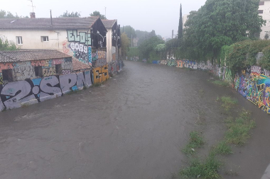
Urban waters (OBSERVIL) : Observation Service of the Montpellier Research Observatory of Environment (OSU OREME)
Data from the 'Urban waters' (OBSERVIL): Observation of precipitation and flooding, runoff and contaminant transport and urban hydrogeology monitoring in Montpellier.. This observatory is part of the Montpellier Research Observatory of Environment (OSU OREME, oreme.org). It is labelized in the framework of SNO OBSERVIL.
Simple
- Date (Revision)
- 2025-08-21
- Date (Creation)
- 2019-01-01
- Identifier
-
12391694-0667-4275-b56a-4c959cf96a90
- Status
- On going
- Maintenance and update frequency
- irregular Irregular
-
GEMET
-
AGROVOC
- Theme
-
-
OBSERVIL
-
SNO OBSERVIL
-
- Access constraints
- otherRestrictions Other restrictions
- Other constraints
-
Licence ouverte / Open Licence
- Use limitation
-
The supply partner is not in a position to guarantee the correctness, up-to-dateness, completeness or accuracy of the data and in particular that it is free from errors or inaccuracies, in particular in the location, identification or qualification.
No guarantee for the suitability of the data for a particular purpose is given by the supplying partner. The users use the data under their full responsibility, without possible recourse against the partner supplier whose responsibility could not be committed because of a damage resulting directly or indirectly from the use of these data.
In particular, it is up to the users to appreciate, under their only responsibility: the advisability to use the data; the compatibility of the files with their data-processing systems; the adequacy of the data with their needs; that they have the sufficient competence to use the data.
The partner supplier is in no way responsible for elements external to the data and in particular for the analysis tools, hardware, software, networks, etc., used to consult and/or process the data.
The user shall ensure that the information made available is up to date and compatible with the use he or she makes of it.
Free use subject to the obligatory mentions on any document of diffusion: "Source: SNO Observil".
- Use limitation
-
This work is licensed under the Licence ouverte / Open Licence ( https://www.etalab.gouv.fr/licence-ouverte-open-licence )
- Spatial representation type
- vector Vector
- Metadata language
- EnglishEnglish
- Character set
- utf8 UTF8
))
- Begin date
- 2019-01-01T00:00:00
- End date
- 2025-04-10T00:00:00
- Reference system identifier
-
EPSG
/4326
- Topology level
- geometryOnly Geometry only
- Geometric object type
- surface Surface
- Geometric object count
- 5
- Distribution format
-
-
CSV
()
-
- OnLine resource
-
See OBSERVIL data on OSU OREME data portal
(
WWW:LINK-1.0-http--link
)
- OnLine resource
-
See OBSERVIL information on OSU OREME website
(
WWW:LINK-1.0-http--link
)
- OnLine resource
-
observil_station
(
OGC:WMS
)OBSERVIL stations WMS
- OnLine resource
-
observil_station
(
OGC:WFS
)OBSERVIL stations WFS
- Hierarchy level
- dataset Dataset
Conformance result
- Date (Publication)
- 2010-12-08
- Explanation
-
See the referenced specification
- Pass
- Yes
Conformance result
- Date (Publication)
- 2008-12-03
- Explanation
-
See the referenced specification
- Pass
- Yes
- Statement
-
Measurements: Automated measurements of precipitation amount
- File identifier
- 12391694-0667-4275-b56a-4c959cf96a90 XML
- Metadata language
- EnglishEnglish
- Character set
- utf8 UTF8
- Hierarchy level
- dataset Dataset
- Date stamp
- 2025-08-21T12:00:00
- Metadata standard name
-
ISO 19115:2003/19139
- Metadata standard version
-
1.0
- Dataset URI
-
OSU-OREME-OBSERVIL
Overviews
Spatial extent
Provided by