Larzac observatory (GEK) : Observation Service of the Montpellier Research Observatory of Environment (OSU OREME)
Data from the 'Larzac observatory' (GEK): Study of the spatio-temporal variations of the water stock in karst environments (Larzac): temperature, water flow, gravimetry, GPS, inclinometry, water vapor, CO2 flow, .... This observatory is part of the Montpellier Research Observatory of Environment (OSU OREME, oreme.org). It is labelized in the framework of SNO H+.
Simple
- Date (Revision)
- 2025-08-21
- Date (Creation)
- 2006-01-09
- Identifier
-
263fe8c1-81cc-425f-be1a-01276a6df96c
- Status
- On going
- Maintenance and update frequency
- irregular Irregular
-
GEMET
-
AGROVOC
- Theme
-
-
GEK
-
larzac causse
-
Hydrogeophysics
-
SNO H+
-
- Access constraints
- otherRestrictions Other restrictions
- Other constraints
-
Licence ouverte / Open Licence
- Use limitation
-
Raw data do not show any guarantee of quality. Higher levels of data are processed and validated for applications in geosciences. Please contact oreme-gek@umontpellier.fr for details on treatments and references.
- Use limitation
-
The reliability and availability of data are not guaranteed and the data can not be used for operational applications.
- Use limitation
-
The agencies or institutions funding data collection and the data centres have to be acknowledged in any publication or communication using the data with the following sentence: "All measurement presented here are from the Larzac observatory, which is the geophysical observatory of karstic water hosted by OSU OREME ( http://www.oreme.org ) and SNO H+ ( http://hplus.ore.fr/ ). Larzac observatory and instrumentation are principally funded by CNRS-INSU, ANR, UM, RESIF and Occitanie region." The reliability and availability of data are not guaranteed and the data can not be used for operational applications.
- Use limitation
-
This work is licensed under the Licence ouverte / Open Licence ( https://www.etalab.gouv.fr/licence-ouverte-open-licence )
- Spatial representation type
- vector Vector
- Metadata language
- EnglishEnglish
- Character set
- utf8 UTF8
))
- Begin date
- 2006-01-09T00:00:00
- End date
- 2025-08-05T00:00:00
- Reference system identifier
-
EPSG
/4326
- Topology level
- geometryOnly Geometry only
- Geometric object type
- surface Surface
- Geometric object count
- 5
- Distribution format
-
-
CSV
()
-
- OnLine resource
-
See GEK data on OSU OREME data portal
(
WWW:LINK-1.0-http--link
)
- OnLine resource
-
See GEK information on OSU OREME website
(
WWW:LINK-1.0-http--link
)
- OnLine resource
-
gek_station
(
OGC:WMS
)GEK stations WMS
- OnLine resource
-
gek_station
(
OGC:WFS
)GEK stations WFS
- Hierarchy level
- dataset Dataset
Conformance result
- Date (Publication)
- 2010-12-08
- Explanation
-
See the referenced specification
- Pass
- Yes
Conformance result
- Date (Publication)
- 2008-12-03
- Explanation
-
See the referenced specification
- Pass
- Yes
- Statement
-
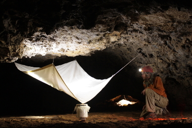
Measurements: Borehole tiltmeter ; Continuous spring relative gravimeter ; Continuous superconducting relative gravimeter ; CTD ; Data logger ; Electrical sounding ; Flux tower ; Free-fall absolute gravimeter ; GNSS ; Long base tiltmeter ; Piezometer ; Quantum absolute gravimeter ; Rain gauge ; Sap flow ; Seismometer ; Spontaneous Potential ; Spring relative gravimeter ; Temperature and soil humidity sensor.
- File identifier
- 263fe8c1-81cc-425f-be1a-01276a6df96c XML
- Metadata language
- EnglishEnglish
- Character set
- utf8 UTF8
- Hierarchy level
- dataset Dataset
- Date stamp
- 2025-08-21T12:00:00
- Metadata standard name
-
ISO 19115:2003/19139
- Metadata standard version
-
1.0
- Dataset URI
-
OSU-OREME-GEK
Overviews
Spatial extent
Provided by