Littoral and shoreline observatory (LTC) : Observation Service of the Montpellier Research Observatory of Environment (OSU OREME)
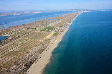
Data from the 'Littoral and shoreline observatory' (LTC): Coastline observation and coastal hydro-morphodynamics (swell, submersion, sediment transport, ...) and coralligenous reefs monitoring in the Mediterranean.. This observatory is part of the Montpellier Research Observatory of Environment (OSU OREME, oreme.org). It consists in different observing tasks: Coastal seismology.
Simple
- Date (Revision)
- 2025-08-21
- Identifier
-
10.15148/7d5e2f17-bad6-4ac3-87e2-84888d0d6699
- Status
- On going
- Maintenance and update frequency
- irregular Irregular
-
GEMET
-
AGROVOC
- Theme
-
-
LTC
-
Submersion
-
- Access constraints
- otherRestrictions Other restrictions
- Other constraints
-
Licence ouverte / Open Licence
- Use limitation
-
This work is licensed under the Licence ouverte / Open Licence ( https://www.etalab.gouv.fr/licence-ouverte-open-licence )
- Spatial representation type
- vector Vector
- Metadata language
- EnglishEnglish
- Character set
- utf8 UTF8
))
- Reference system identifier
-
EPSG
/4326
- Topology level
- geometryOnly Geometry only
- Geometric object type
- surface Surface
- Geometric object count
- 5
- Distribution format
-
-
CSV
()
-
- OnLine resource
-
See LTC data on OSU OREME data portal
(
WWW:LINK-1.0-http--link
)
- OnLine resource
-
See LTC information on OSU OREME website
(
WWW:LINK-1.0-http--link
)
- OnLine resource
-
Associated data with DOI
(
WWW:LINK-1.0-http--link
)
- OnLine resource
-
ltc_station
(
OGC:WMS
)LTC stations WMS
- OnLine resource
-
ltc_station
(
OGC:WFS
)LTC stations WFS
- Hierarchy level
- dataset Dataset
Conformance result
- Date (Publication)
- 2010-12-08
- Explanation
-
See the referenced specification
- Pass
- Yes
Conformance result
- Date (Publication)
- 2008-12-03
- Explanation
-
See the referenced specification
- Pass
- Yes
- Statement
-
Measurements: Houlographic buoy ; Hydrodynamics (waves, water levels, lagoon and neashore circulation) and meteorology
- File identifier
- c8d72716-d3ad-492c-9e4c-61cba1fb638d XML
- Metadata language
- EnglishEnglish
- Character set
- utf8 UTF8
- Hierarchy level
- dataset Dataset
- Date stamp
- 2025-08-21T12:00:00
- Metadata standard name
-
ISO 19115:2003/19139
- Metadata standard version
-
1.0
- Dataset URI
-
OSU-OREME-LTC
Overviews
Spatial extent
Provided by